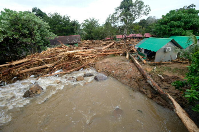
Damaged chalets are pictured near Titi Hayun following flash floods in Yan, Kedah August 19, 2021. — Bernama pic
ALOR SETAR, Aug 20 — The incident in the Gunung Jerai area that resulted in mudslides and floods on Wednesday was not caused by the water surge phenomenon but is attributed to a debris flow incident which is a common occurrence in mountainous areas.
Principal Research Fellow at Institute for Environment and Development (Lestari), Universiti Kebangsaan Malaysia (UKM) Prof Emeritus Datuk Dr Ibrahim Komoo said a debris flow is a more accurate description for the incident due to abnormally heavy rainfall in the area.
He said water surges occur when an unusually high volume of rainfall flows into the riverbeds which are interrupted due to sediments and debris, causing the water level to go up several metres.
“Meanwhile a debris flow formed when water is mixed with soil and forests debris that move rapidly downwards entering the riverbeds until it reaches the foothill,” he told Bernama today.
On Wednesday, the area around Gunung Jerai was hit by mudslides and landslides due to a sudden rush of water which resulted in four deaths with two victims still missing.
The disaster caused damages to properties and facilities as well as affected residents in the town nearby as it became inundated with mud.
Ibrahim said the incident would take a long time to recur as the area has been cleared of debris such as fallen trees that would result in an uninterrupted flow of rainwater.
He said a similar incident had happened before in Pos Dipang, Perak in 1996 which destroyed an Orang Asli village and killed 44 people.
“An almost similar incident happened at Genting Sempah in 1995 that killed many people.
He added that it was a natural phenomenon and had nothing to do with logging activities.
Environmental hydrologist and river modelling expert Prof Datuk Dr Mohd Ekhwan Toriman said satellite images did not detect any logging or large-scale agricultural activities in the Gunung Jerai area.
He said water surges due to rainfall would bring with it wood debris, stones and silts which would cause mud floods up to 1.5 metres deep at the foothills.
He speculated that the Gunung Jerai incident was probably caused by debris that had accumulated and formed a dam in the upper reaches of the river, adding that an abnormally heavy rainfall collected more debris and became stuck in the natural dam.
“High pressure had caused the dam to break, bringing with it debris, rocks, wood debris, sediments and silts,” he said.
He said rainfall distribution at the rainfall stations in Gunung Jerai and Kampung Singkir Genting recorded 218 millimetres (mm) and 172 mm of rainwater during the incident.
Meanwhile, Institute of Geology Malaysia (IGM) president Abd Rasid Jaapar in a statement said a thorough study and action plan must be developed utilising the concept of disaster risk reduction in line with good international practices as outlined by the Sendai Framework for Disaster Risk Reduction 2015-2030 by the United Nations Office for Disaster Risk Reduction (UNDRR).
He said a complete and independent geology disaster study should be carried out in Gunung Jerai and the surrounding area. ― AFP


