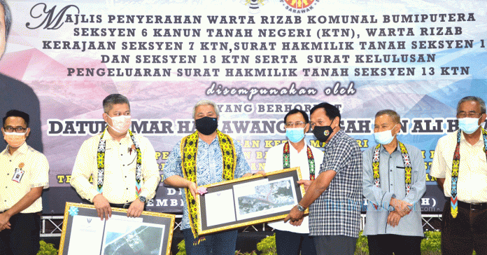
BINTULU, Dec 16 ― The Gabungan Parti Sarawak (GPS)-led state government under Chief Minister Datuk Patinggi Abang Johari Tun Openg has always recognised and protected the rights of the people over their native customary rights (NCR) land if their claims are legally valid, says Deputy Chief Minister Datuk Amar Awang Tengah Ali Hasan.
In fact, he said, efforts to survey and issue titles for NCR land had been done by the state government since the 1960s until 2010.
However, he said the method used from 1960 to 2010 was found to be slow.
“Only about 260,000 hectares (642,460 acres) of NCR lands were successfully surveyed.
“On average, only 5,200 hectares could be surveyed per year while the demand from the people was huge,” he said during the presentation of land titles under Section 18 of the Sarawak Land Code at Bintulu Civic Centre yesterday.
Awang Tengah, who is Second Minister of Urban Development and Natural Resources, and Minister of International Trade and Industry, Industrial Terminal and Entrepreneur Development, said the state government had expedited the survey process through the NCR Land Measurement New Initiative since 2010.
He said the programme was implemented in two stages.
The first stage is perimeter survey to gazette land under Section 6 of the Sarawak Land Code as Bumiputera Communal Reserve (Agriculture).
The second stage is individual lot survey and issuance of land title under Section 18 of the Sarawak Land Code.
“To-date a total of 38,614 individual lots have been surveyed involving 48,476 hectares (119,786 acres) which have been and will be issued with land titles under Section 18 of the Sarawak Land Code,” he said.
He also said the survey is based on approved NCR land applications and dialogues were held with the NCR land owners before the survey could begin.
“It aims to provide information and to get feedback before the actual field survey work is carried out,” he added, pointing out that the survey would only be carried out after obtaining the consent and support of the land owners.
For cases that are still in dispute and in court, he said survey works would not be carried out unless the case has been resolved or withdrawn by those involved.
And if they are still interested in getting their land surveyed, they must submit a new application, he added.
He disclosed that from 2010 to 2020, the Sarawak Land and Survey Department had successfully done perimeter survey on 965,285 hectares (2.385 million acres) of NCR land, of which 753,456 hectares or 1.8 million acres had been gazetted.
“This is an efficient surveying programme and important in determining clearly the boundary of the NCR land as Bumiputera Communal Reserve under Section 6 of the Sarawak Land Code,” the Deputy Chief Minister pointed out.
During the event, five areas received their Bumiputera Communal Reserve Gazette; namely Nanga Menua, Ulu Anap Tatau; Selezu B; Sungai Sap, Sangan Tatau; Kampung Melayu Tubau and Lavang Sebauh, Jalan Bintulu-Bakun.
A total of 189 land titles were presented to 179 recipients from Kelawit, Senunok and Kuala Tatau.
Awang Tengah said the traditional village surveying programme was still ongoing to recognise villages that had long existed either in areas that had been gazetted as Bumiputera Communal Reserves or had not been gazetted.
“So far, a total of 55,849 residential lots in 360 villages throughout Sarawak have been surveyed. Of the total, 50,517 lots have been issued land titles under Section 18 of the Sarawak Land Code,” he added.
In Bintulu seven villages were presented with the Bumiputera Communal Reserve Gazette under Section 6; namely Kampung Sinong, Kampung Masjid, Kampung Dato, Kampung Sibiew, Kampung Kemunting, Kampung Jepak Hulu and Kampung Baru, including Government Reserve Gazette under Section 7 of Sarawak Land Code for Kampung Nelayan Batu Mandi, Bintulu.
At the same time, 39 land titles under Section 18 of Sarawak Land Code were presented to 36 people from Kampung Kemunting.
Also presented were 29 land titles under Section 13 of Sarawak Land Code to 21 people in Kuala Tatau for agriculture purposes.
A total of 497 approval letters for the issuance of land title under Section 13 in the ex-settlement area in Tengan, Pelapi and Jalan Bintulu-Miri for agricultural purpose were also handed over to 481 recipients.
Among those present at the event were Minister of Utilities Datuk Seri Stephen Rundi Utom, Minister in the Chief Minister’s Department (Integrity and Ombudsman) Datuk Talib Zulpilip, Assistant Minister of Native Laws and Customs Datuk John Sikie Tayai, Assistant Minister of Urban Planning, Land Administration and Environment Datu Len Talif Salleh, Samalaju assemblyman Majang Renggi, Sarawak Land and Survey Department deputy director (Management) Awang Zamhari Awang Mahmood, Bintulu Resident Jack Aman Luat, Bintulu Development Authority general manager Muhammad Yakup Kari and Bintulu Land and Survey superintendent Mohammad Zunica Mohamad Sapi’ee. ― Borneo Post


